
Sierra National Forest

PHOTO BY ADAM BLAUERT
National forests
Yosemite National Park is surrounded by national forest lands. To the northwest, the Stanislaus National Forest provides some of the closest mountain recreation for those of us in the Central Valley. On the opposite side of the Merced River, the Sierra National Forest provides equally close mountains.
When you drive to Yosemite on Highway 140 you are on the Sierra National Forest side of the river canyon for most of the journey. Directly across the water is Stanislaus National Forest.
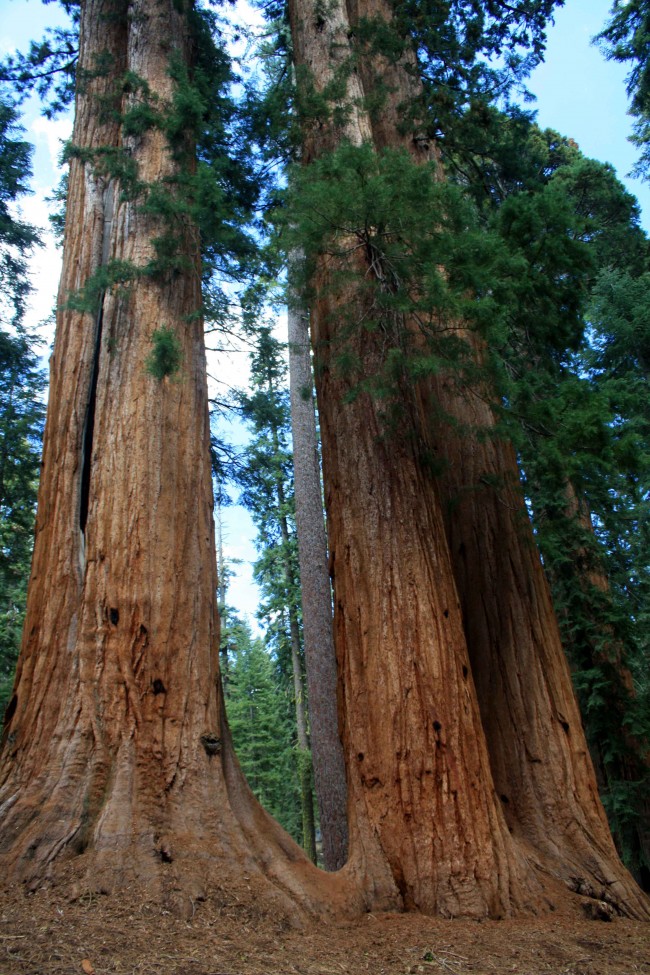
McKinley Grove - PHOTO BY ADAM BLAUERT
McKinley Grove
The Park between Yosemite National Park and Kings Canyon National Park
The name “Sierra National Forest” can be confusing because the Sierra Nevada mountain range stretches all the way from Highway 36 east of Chico to Tehachapi Pass (Highway 58) in the south.
Sierra National Forest comprises only part of this area – specifically the area between Yosemite National Park and Kings Canyon National Park. Its 1.3 million acres of land provide just about every type of outdoor recreation imaginable. From dry foothills to snowbound windswept peaks it is a glorious place to explore.
Just as with its vast northern neighbor Stanislaus National Forest, the question “What do you do there?” requires a long answer. This article is an effort to answer that question and to provide a list of useful resources for learning about the forest and its recreational opportunities.
One of the best resources to start with is the annual visitor guide produced by Sierra National Forest
website: http://www.3forests.us/

Shaver Lake - PHOTO BY ADAM BLAUERT
Shaver Lake
Popular recreational activities within Sierra National Forest include
Auto touring
Staying in developed recreation areas within and near the forest
Hiking and backpacking in wilderness areas
Hiking trails outside of wilderness areas
Camping
Ranger-led activities
Fishing
Boating
Swimming
Hiking and camping with dogs
Horseback riding
Mountain biking
OHV riding and exploring 4-wheel drive roads
Hunting
Downhill skiing
Playing in the snow
Cross-country skiing and snowshoeing
Snowmobiling
Within the forest there are many privately owned areas. Some of these offer additional recreational opportunities plus tent and RV campgrounds, lodging, restaurants, stores, and gas stations.

Kaiser Pass Road View - PHOTO BY ADAM BLAUERT
Kaiser Pass Road View
Ranger Stations
The Sierra National Forest Headquarters is located at 1600 Tollhouse Road in Clovis. You can get general forest information and recreation permits by contacting the headquarters.
The phone number is (559) 297-0706 and the general website for the entire forest is www.fs.usda.gov/sierra/.
The forest is divided into districts which can provide more specific information about their respective areas
High Sierra District: 29688 Auberry Road, Prather –(559) 855-5355
Bass Lake District: 57003 Road 225, North Fork – (559) 877-2218
Yosemite Sierra Visitor Bureau: 41969 Highway 41, Oakhurst – (559) 683-4636
Mariposa Interagency Visitor Center: 5158 Highway 140, Mariposa –
(209) 966-7081
Eastwood (seasonal): Highway 168 and Kaiser Pass Road, Huntington Lake –
(559) 893-6611
Dinkey Creek (seasonal): Dinkey Creek Road at Dinkey Creek – (559) 841-3404
High Sierra (seasonal): Kaiser Pass Road – (559) 877-7173

Ansel Adams Wilderness - PHOTO BY ADAM BLAUERT
Ansel Adams Wilderness
Road Access and Auto Touring
Unlike the national forests to the north, no road crosses the entire mountain range within Sierra National Forest. Highway 168, the major state highway in the area, penetrates deep into the mountains and the Kaiser Pass Road to Edison and Florence Lakes approaches the crest, but there is no automobile crossing. This leaves plenty of room for exploration on foot or horseback.
A number of secondary roads ranging from two-lane paved roads to rough four-wheel drive roads provide plenty of additional access. Besides Highway 168 and Kaiser Pass Road, the paved roads to Courtright and Wishon Reservoirs are great scenic drives.
The partially-paved 100-mile Sierra Vista Scenic Byway is also a great choice for auto touring. Usually the road can be traversed by any car if driven carefully, but high-clearance is recommended.
For more information about the byway go to www.sierravistascenicbyway.org/
Major Towns, Supplies, Lodging, Food, and Gas
The major supply and service locations are adjacent to the major roads. Each of the major routes has chambers of commerce and/or business associations with websites for information about lodging, food, supplies, gas, local activities, and special events.
I’ve listed them below in order from north to south:
Highway 140 ~ Mariposa, El Portal
Highway 41 ~ Oakhurst, Sugar Pine, Fish Camp
Sierra Vista Scenic Byway ~ Bass Lake, North Fork, South Fork
Highway 168 and Kaiser Pass ~ Shaver Lake, Huntington Lake, Edison Lake

Courtright Reservoir - PHOTO BY ADAM BLAUERT
Wilderness Areas
Five wilderness areas are within or partly within the boundaries of Sierra National Forest. They offer some of California’s best hiking, backpacking, and fishing. They are also great places to enjoy abundant and brilliant wildflowers and to see a variety of wildlife in its natural habitat.
Ansel Adams Wilderness
Named for the photographer whose timeless images turned the Sierra Nevada’s striking landscapes into universally-recognized icons, this great wilderness area makes up much of the northeastern section of Sierra National Forest. With stunning mountain peaks, alpine lakes, and the headwaters of the San Joaquin River, the Ansel Adams Wilderness has a lifetime of trails to explore.
Dinkey Lakes Wilderness
One of the smaller wilderness areas in the forest, this often-overlooked region has many lakes and surprisingly easy day hike and backpacking destinations.

Dinkey Lakes Wilderness - PHOTO BY ADAM BLAUERT
Dinkey Lakes Wilderness
Note: the lakes are not “dinkey” in size; the wilderness was named for a dog named Dinkey who saved a pioneer from a grizzly bear attack.
John Muir Wilderness
The protection of the Sierra Nevada Mountains is largely due to the work of naturalist John Muir and it is only fitting that one of the largest wilderness areas in the range bears his name.
The eastern part of the wilderness is part of Inyo National Forest. This area contains some of the highest peaks in the lower 48 states, glaciers, an amazing number of lakes, and excellent fishing.
Kaiser Wilderness
This is a small wilderness area that is largely unknown outside the Fresno area. Centered around Kaiser Peak and north of Huntington Lake, the area contains several small lakes. Trails are generally more challenging than the equally-sized Dinkey Lakes Wilderness.
Monarch Wilderness
At the southernmost edge of Sierra National Forest, this small and almost unknown wilderness is mostly located within Sequoia National Forest and the Giant Sequoia National Monument. Although it lacks lakes and contains some extremely rugged terrain it is a place where solitude is likely to be found among old growth giant sequoias.
Trails Outside of Wilderness Areas
A number of excellent trails are found outside of the wilderness areas. Details can be found in some of the books listed below. Some of the most popular non-wilderness trails are within the forest’s two groves of giant sequoias:
Nelder Grove
On the northern edge of the forest north of Oakhurst, this partially-logged grove still has several impressive trees.
For more information go to: http://www.neldergrove.org/
McKinley Grove
Located along the McKinley Grove Road between Dinkey Creek and Wishon Reservoir. An easy walk through the trees is a trail that is within just about anyone’s ability range.
For more information go to: www.fs.usda.gov/Internet/FSE_DOCUMENTS/stelprdb5344073.pdf
Books, Maps, and Other Resources
Although web-based resources are great for planning a trip, cellular service, internet, and electric power are hard to come by in much of the forest.
If you can store electronic resources on your device and have well-charged batteries, you may be able to continue to access your information this way. It’s always good, however, to have some paper resources.
Print out information from the internet and bring both maps and books. The general guide produced by Sierra National Forest is invaluable to have with you, especially if your plans change while on a trip.
Weather and other elements outside of your control often require flexibility.
You can access and print that guide here: www.3forests.us/sierra
Books
Unfortunately there is no single book that comprehensively covers this area. For backpacking, Sierra South from Wilderness Press is a great choice.
For shorter day hikes, pick up a copy of California Hiking by Stienstra and Brown. Not only does this book highlight the best day hikes in Sierra National Forest, it is also an excellent resource for the entire state with a total of 1,000 hike routes.
Hiking the Sierra Nevada by Barry Parr is also a good choice.
Maps
It’s good to have a general highway map, but if you plan to explore off the main roads the Sierra National Forest Map is one of the most important things to have with you.
In addition to roads and trails, it also shows campgrounds, ranger stations, supply locations, and recreation areas. It supplements the general guide to the forest (see above).
You can buy it from the U.S. Geological Survey for $12: store.usgs.gov from a variety of other online retailers. You can also purchase it at a ranger station.
For hiking or backpacking, the following maps are the top choices: No matter what resources you use, always call a ranger station to verify current conditions before you leave on a trip. Conditions are always changing and even the official websites can be badly out of date.
Ansel Adams Wilderness published by Tom Harrison Maps
(I generally prefer Tom Harrison’s maps because they have the mileage directly written on each trail segment – this makes for easier trip planning. They are also waterproof).
Dinkey Lakes Wilderness published by Tom Harrison Maps
Mono Divide High Country Trail Map published by Tom Harrison (covers most of the John Muir Wilderness)
A Guide to the Kaiser Wilderness published by the US Forest Service
For more detailed hiking maps, check the USGS website for 7.5 and 15 minute sections.
You can order printed copies of these maps or download free electronic copies.

Edison Lake - PHOTO BY ADAM BLAUERT
Edison Lake
Campground Camping
Within Sierra National Forest you’ll find 82 campgrounds.
Most are detailed in the forest guide: www.3forests.us/sierra
Some campgrounds are reservable in advance. You can search for reservable campsites by going to: www.recreation.gov.
Dispersed Camping
Camping outside a campground (usually referred to as “dispersed camping”) is permitted in areas of the forest where signs do not specifically prohibit it.
You can always check with a ranger station before you set up camp. In order to have a campfire you need a California Campfire Permit, available at any ranger station.
You can also take an online quiz and get one issued electronically by going to:
http://www.fs.usda.gov/sequoia/
As long as you follow the rules on the permit and make sure that you have chosen a safe site, your campfire is legal. Before your trip you should also make sure that additional campfire restrictions have not been put in place.
In dry years campfires are sometimes prohibited outside of established campgrounds. This year is no different and some limitations have been imposed.
Ranger-Led Activities
A variety of programs and hikes for all ages and ability levels are offered throughout the year. For current schedules call the ranger district that you plan to visit.
Fishing
The forest abounds with streams, rivers, natural lakes, and reservoirs. Many are stocked and most are open to fishing.
For regulations and stocking information, go to www.dfg.ca.gov. Tom Stienstra’s California Fishing is a good general guide to the whole state, including Sierra National Forest.
Boating
Motorized fishing boats area allowed on the following lakes: Bass, Courtright, Edison, Florence, Huntington, Mammoth Pool, Pine Flat, Redinger, Shaver, and Wishon. Water skiing and jet skis are allowed at Bass, Huntington, Pine Flat, Redinger, and Shaver.
Swimming
Swimming is allowed in most streams, rivers, and lakes, however it can be dangerous. Make sure that all people in your group have strong swimming abilities and you have flotation devices in case a rescue is necessary. Check with a ranger for current conditions and recommended areas.
Dogs
Dogs are welcome on trails and in campgrounds in national forests as long as they are on-leash and well-behaved. They are not permitted on trails in state or national parks. Dogs may be off-leash as long as they are under voice control within wilderness areas (except in bighorn sheep habitat areas – check with a ranger station if you are planning a backpacking trip with a dog).
Horses
Horses are permitted on trails within the national forest. For overnight trips they must be included on your wilderness permit. Check with the ranger station for the best trail parking for horse trailers. Day rides and overnight pack trips are offered by:
D&F Pack Station: http://dandfpackstation.squarespace.com/
High Sierra Pack Station: http://www.highsierrapackstations.com/index.html
Horse Corral Pack Station: http://www.highsierrapackers.org/horse.htm
Minarets Pack Station: http://www.highsierrapackers.org/min.htm
Muir Trail Ranch: http://www.muirtrailranch.com/horses.html
Shaver Lake Stables: http://www.shaverstable.com/
Yosemite Trails Pack Station: http://www.yosemitetrails.com/
If you are not up to carrying all your gear or if you want to enjoy the wilderness with in a less strenuous way, a pack trip is a good choice.
Mountain Bikes
All roads and most trails outside of wilderness areas are open to mountain bikes. Check with a ranger for recommended trails and roads.
Off-Highway Vehicles and 4-Wheel Drive Vehicles
Many remote forest roads require 4-wheel drive and several areas are open to off-highway vehicles.
A copy of the Sierra National Forest map is extremely helpful in locating the best sites.
Hunting
The forest, including wilderness areas, is open to hunting according to DFG regulations. You can check regulations at www.dfg.ca.gov. Target shooting is prohibited in wilderness areas.
Winter Activities
Some roads and campgrounds are open through the winter months, especially in the lower elevations. Always carry tire chains and know how to install them. Highways 41, 140, and 168 are open throughout the winter except for temporary snow closures.
Most other roads are closed. Many lodging facilities are open year-round.
Downhill skiing and snowboarding
Offered at China Peak on Highway 168 at Huntington Lake. For more information: www.skichinapeak.com/
Snow Play Areas
Sierra National Forest is also a popular destination to play in the snow. Five “Sno-Parks” offer snow recreation for a $5 use fee. Permits must be purchased before you reach the Sno-Park. Look for signs as you drive up Highway 168 or call the ranger station for a current listing.
Snowshoeing and cross-country skiing
Along trails is also popular. Occasionally ranger-led snow activities are offered. Check with the ranger station for details. If none are offered, try Yosemite or Sequoia National Parks.
To find your own route, pick up a copy of Best Snowshoe Trails of California by Mark White.
Snowmobile Trails
For snowmobiling information go to www.fs.usda.gov/detail/sierra/recreation/wintersports/?cid=stelprdb5303598
or call the ranger station.
Adam Blauert, a high school teacher and avid outdoors enthusiast, has dedicated the majority of his life to Merced County. His passions include fishing, backpacking, delving into local history, and exploring the wonders of the western states.