
Top 5 Things to do in the Spring in and Around Merced County

Photo By Adam Blauert
Springtime
According to the system by which seasons are calculated, spring doesn’t officially begin until March 20th this year. Signs of the new season, however, start with the first blossoms on flowering trees in town and in the county’s orchards.
The almond trees are the first major orchard tree to bloom, usually starting by mid-February and peaking towards the end of the month. Their bloom was early this year and is already over, but the peach bloom is currently in its prime.
1. Blossom tours
Blossom tours are a great way to enjoy the outdoors at the time when winter is fading into spring. Looking for something relaxing to do in the outdoors?

Photo By Adam Blauert
Take a drive on the rural roads of our county and enjoy the blossom display. For the driving directions and a map to the county’s driving (or biking) tour of peach blossoms, use the following links provided by the UC Extension program:
Description: http://cemerced.ucanr.edu/files/40627.pdf
Map: http://cemerced.ucanr.edu/files/40628.pdf
Peach blossoms are a vibrant pink and they photograph nicely, especially in the warm light that often comes as sunlight breaks through clouds. For an enjoyable drive, pack water, jackets, snacks, cameras, and sunglasses.

Photo By Adam Blauert
Remember that orchards are private property and you should stay along the road unless the property owner invites you onto his/her property. You can enjoy the blossoms and get great photos without venturing from the side of the road. You can find a lot of additional information about blossom tours by clicking here. This is something to do the first week of March before the blossoms fall. Not all orchards bloom at exactly the same time, so some will already be losing their blossoms when you go, but you are guaranteed to find some that still have vibrant displays through the second week of March.
2. Bike Ride
Enjoying a bike ride on a local bike path is another one of the joys of spring. The temperature is nice, the skies are usually blue, and plants and trees are coming back to life. It’s a beautiful and comfortable time to be outdoors. Explore the town on one of the city’s bike paths. My favorites are the Bear Creek loop between McKee Road and G Street and the path that follows Lake Road between Yosemite Avenue and Lake Yosemite.
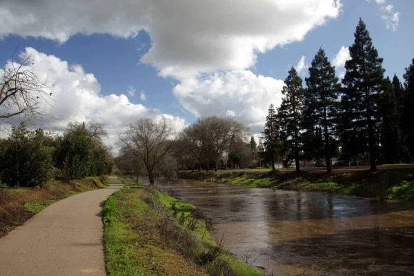
Photo By Adam Blauert
More experienced bikers can enjoy riding rural roads throughout the county, but the bike paths provide a safe environment for riding with family members, especially small children.
For a downloadable map of bike paths in Merced:
City of Merced city bikeway map (click here)
Merced bike paths on Google Maps (click here)
For more information about bike routes throughout the county, click here .
3. Wildflower driving tours
After the orchard blossoms fall to the ground, wildflower season kicks into gear in our local foothills. You can enjoy them easily on a short driving trip to Mariposa County. Although late March through early May is usually the best time for wildflowers, this year they have arrived early.

Photo By Adam Blauert
I recommend heading up to Mariposa County on Highway 140 and then exploring some of the back roads such as:
Old Highway (the original Highway 140 between Catheys Valley and the Mariposa Fairgrounds)
Yaqui Gulch Road
Ben Hur Road
Indian Gulch Road
Bear Valley Road
Old Toll Road
Pendola Garden Road
Mt. Gaines Road
Hunters Valley Road
Briceburg Road
Twelve miles east of downtown Mariposa, the Briceburg road is a left-hand turn from Highway 140. It is often one of the best places to see California poppies. The Merced River Canyon between Briceburg and the entrance to Yosemite can also have very nice displays.
All you need is a full tank of gas, a map of Mariposa County, water, jackets, snacks, cameras, and sunglasses.
You can pack a picnic lunch or try one of the many restaurants in Mariposa. You can see great wildflower displays from the side of the road without trespassing, so please make sure that you obey all posted signs and avoid venturing onto private land.
4. Local hikes
You can enjoy more wildflowers and more views on foot. Here are five favorite places to hike in the spring:
Hite Cove: Probably the most popular wildflower hike in our area, this trail starts 20 miles east of Mariposa on the east side of Highway 140.

Photo By Adam Blauert
After the highway crosses the South Fork of the Merced River, look for a parking area on the west side of the roadway. The trail starts by climbing a paved roadway and then becomes a narrow dirt path with a steep drop-off down to the river. Some of the best wildflowers are usually found along the first half mile, so you don’t have to hike far. If you’re up for a longer hike, however, you can follow it for 3 ½ miles to Hite Cove, a bend in the river where a mining community thrived in the 1860s. A few rock walls and pieces of rusted iron machinery remain.
Table Mountain (Tuolumne County): Located near Jamestown, this hike involves a steep climb to the top of the iconic table that follows Highway 108 and the course of an ancient channel of the Stanislaus River. The trail climbs through oaks to the flat tabletop for excellent views of the surrounding hills and valleys. Wildflowers shows on top of the table can be excellent, especially in wet years. The round-trip hike is about 3 miles with 400 feet of elevation gain.
For more information and maps, call the Bureau of Reclamation at (209) 536-9094 or go to http://www.usbr.gov/mp/ccao/newmelones/. There is no fee to park or use this area.
Pacheco State Park: Although most of the best wildflower hikes are located in the Sierra foothills, the Coast Range also often has some great displays.

Photo By Adam Blauert
Pacheco State Park, located on the south side of Highway 152 about 15 1/2 miles west of I-5, has nearly 30 miles of hiking trails where wildflowers may be enjoyed. For more about Pacheco State Park click here.
For more information go to http://www.parks.ca.gov/?page_id=560
or call (209) 826-1197
The day use fee is $10/vehicle.
Path of the Padres: Also on the west side of the Central Valley, the Path of the Padres is another of the top local wildflower destinations. This trail starts at Los Banos Creek Reservoir and is only accessible on guided hikes, offered regularly in February, March, and April of each year.
For reservations, call (209) 826-1197.
The docents who lead these hikes know a lot about the area’s human and natural history and participating in a hike is a great way to learn. There is a $12/person fee for the guided hike, which lasts most of the day and totals about 5 ½ miles round trip after crossing the reservoir on a pontoon boat.
There is a per person fee for the guided hike, which lasts most of the day and totals about 5 ½ miles round trip after crossing the reservoir on a pontoon boat. For more info click here.
Knights Ferry: In the sleepy hamlet of Knights Ferry, pedestrians can still cross the Stanislaus River on a historic covered bridge. The stone and brick walls of buildings from the 1850s and 1860s line the river and an easy pathway along the river provides beautiful views of the town and the canyon. The path is only a 3 mile round trip walk, but it packs in a lot of beautiful scenes.
The trail starts on the north side of town at the end of the main road along the river near the stone and brick shell of the old Tulloch Mill.
For more information, call the Knights Ferry Information Center at 209-881-3517. There is no charge for parking or access to the river, trail, and historic buildings.
There is no charge for parking or access to the river, trail, and historic buildings.

Photo by Adam Blauert
Some of the best foothill hikes are guided outings and classes organized by the Sierra Foothill Conservancy. During the spring months, they offer hikes and classes for all ages and abilities on the preserves and conservation easements that they manage in Mariposa, Madera, and Fresno Counties.
The Mariposa County easements are less than an hour’s drive from Merced.
For more information and a calendar of events:
http://www.sierrafoothill.org/
or call (209) 742-5556.
5. Local camping
Another way to take advantage of the nice weather is to go on a camping trip. There are lots of places to camp locally and they are most enjoyable in the spring and fall.
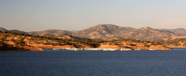
Photo By Adam Blauert
You can get from home to your campsite in less than an hour if you book a site at one of the following parks:
Lakes McClure and McSwain: http://www.lakemcclure.com/ / (855) 800-2267
Lake Don Pedro: http://www.donpedrolake.com/
New Melones: http://www.recreation.gov/ / (877) 444-6777
McConnell State Recreation Area: http://www.reserveramerica.com
Hensley Lake: http://www.recreation.gov/ / (877) 444-6777
Eastman Lake: http://www.recreation.gov/ / (877) 444-6777
San Luis Reservoir: http://www.reserveramerica.com

Photo By Adam Blauert
All of these are located between the floor of the valley and the 1,500 foot elevation level, so weather is similar to Merced.
Beware of rattlesnakes (possible at all except McConnell). Some allow dogs, and fires may be allowed depending on the location and the dryness of the landscape.
Always check current conditions in advance. McClure, Don Pedro, and New Melones are my personal favorites for lakeside camping (Eastman and Hensley currently have extremely low water levels due to the drought).

Photo By Adam Blauert
McConnell is the best place to camp along the lower part of the Merced River.


Adam Blauert, a high school teacher and avid outdoors enthusiast, has dedicated the majority of his life to Merced County. His passions include fishing, backpacking, delving into local history, and exploring the wonders of the western states.